| DIRECTIONS
Directions from Sacramento:
Take I-80 West. Continue until you pass Vacaville, then Fairfield, Cordelia, and the over the hills, down and up a big dip and then take Hwy 37 (exits right) towards San Rafael. (You will see Marine World with its roller coasters as you descend into Vallejo). The exit is just past the rest stop.
Hwy. 37 is under construction in several areas...you will go thru 3 stop lights. Then 37 crosses a small wetland area, up and over a bridge, then across a long wetland area. You will come to a stop light at the junction of 116. Continue thru the light on 37. (Infineon raceway is on the right) Hwy. 37 is now 2 lanes again and passes across a valley and thru another stop light. Past the light you go up and over on another small bridge. The hwy. makes a sweeping turn to the left, then back again to the right. Quickly you will come up on the Black Point Atherton Ave. exit. Exit right. (if you happen to miss this exit, continue on hwy. 37 and join Hwy 101 shortly and take 101 north towards Petaluma and exit Atherton Ave., go left and pick up directions below at ..cross over Hwy 101))
At the stop sign, turn left on to Atherton Ave. This is a short cut that takes you to San Marin Drive. After a few turns, the road is straight, passes a fire station, and eventually swings left. Shortly again, you will reach several lights as you cross over Hwy 101. Continue thru the lights and Atherton Ave. becomes San Marin Drive.
Continue on San Marin Drive for @2.9 miles. You will go through 6 stop signs. At the 6th, you will be at Novato Blvd. & San Marin High School will be on your right.
Turn right (always follow signage to Point Reyes). Continue for 6.3 miles (you will pass Stafford Lake and park shortly and then finally reach a stop sign. (You must turn left or right.) Turn left towards Point Reyes. Continue for 6.9 miles. Shortly you will see a fire station and then the Cheese Factory on your right. (The Cheese Factory has wonderful cheeses and also restrooms). After going over a small pass you will reach lake Nicasio, and then come to a stop sign at a small concrete bridge...currently purple. Turn Right to Point Reyes, which is 3.1 miles.
At the stop sign, you are at Hwy 1. Turn Left and you will go down a hill and into Point Reyes...follow the yellow line and Hwy 1 signs which will take you left thru downtown and the right at the end of town. You will then see signs indicating Lighthouse, Beaches and Inverness. You will cross a green steel bridge and then turn right to Inverness and Beaches. This is Sir Francis Drake Blvd. and it ends at the Lighthouse.
Continue on Sir Francis Drake Blvd for @ 6.4 miles. The road stays near the bay, goes thru Inverness Park, then Inverness, and eventually swings left and heads up a steep grade. At the top of the grade you will see a Point Reyes National Seashore sign on the left and the road continues on the right side of a small meadow. On the right in a short distance you will see a sign indicating a "Y" ahead. The brown park signs on the right will indicate "Lighthouse" to the left, “Tomales Bay State Park and McClures Beach” to the right. You will go right and continue for about 1 mile.
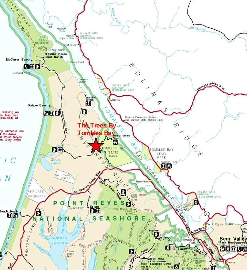
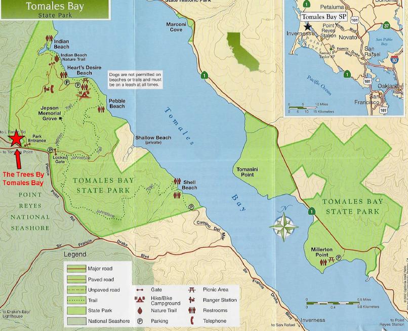
This heads up a short grade and continues along the ridge for a short distance, then makes a sweeping left turn downhill. Tomales Bay State Park "Hearts Desire Beach" entrance is at the bottom of the hill to the right. Slow as you pass the park entrance. Roughly 50 yards past the park entrance a small paved road goes off and up to the right. You will see 3 mailboxes on the right where the road splits off, this is the beginning of our property. This road is called Duck Cove/Marshall Beach Road and there is a large white Dairy sign with the road signs. Another 40 yards up this road on the right you will see a driveway with a big wooden gate wit the address 1214. This is our entrance.
From either 101 or Richmond Bridge:
Exit Sir Francis Drake Blvd. and head west. This will take you thru San Rafael, Ross, San Anselmo, Fairfax and then head up and over a grade into San Geronimo Valley, Lauganitas, etc. In a short while Sir Francis Drake Blvd. enters Samuel P. Taylor State Park, and ultimately head up another steep grade and down the other side into Olema. You will come to a stop sign at Hwy 1. and must turn left or right. The Olema Inn is on your right. Turn right. About 1 block further there is a small road to the left. It is Bear Valley Rd. and is signed for Park Headquarters, Beaches, Lighthouse, etc. Turn Left. This will take you past the Bear Valley Park Headquarters of the National Seashore and will eventually come to a stop sign at a corner. This is again Sir Francis Drake Blvd. You will go straight (slight left) to Inverness and Beaches. Right is to Point Reyes.
Continue on Sir Francis Drake Blvd for @ 5+ miles. The road stays near the bay, goes thru Inverness Park, then Inverness, and eventually swings left and heads up a steep grade. At the top of the grade you will see a Point Reyes National Seashore sign on the left and the road continues on the right side of a small meadow. On the right in a short distance you will see a sign indicating a "Y" ahead. The brown park signs on the right will indicate "Lighthouse" to the left, “McClures Beach and Tomales Bay State Park” to the right. You will go right and continue for about 1 mile.
This heads up a short grade and continues along the ridge for a short distance, then makes a sweeping left turn downhill. Tomales Bay State Park "Hearts Desire Beach" entrance is at the bottom of the hill to the right. Slow as you pass the park entrance. Roughly 50 yards past the park entrance a small paved road goes off and up to the right. You will see 3 mailboxes on the right where the road splits off; this is the beginning of our property. This road is called Duck Cove/Marshall Beach Road and there is a large white Dairy sign with the road signs. Another 40 yards up this road on the right you will see a driveway with a big wooden gate with the address 1214. This is our entrance.
Directions From Hwy 101 in Petaluma:
From 101 exit on Washington St. and go west (right). Go about 5 blocks and then turn left AT Lakeville Rd. At the next block, D Street, turn right. Follow D Street out of town. Continue for about 9 miles where you will see a fire station and then the Cheese Factory on your right. (The Cheese Factory has wonderful cheeses and also restrooms). After going over a small pass you will reach lake Nicasio, and then come to a stop sign at a small concrete bridge...currently purple. Turn Right to Point Reyes, which is 3.1 miles.
At the stop sign, you are at Hwy 1. Turn Left and you will go down a hill and into Point Reyes...follow the yellow line and Hwy 1 signs which will take you left thru downtown and the right at the end of town. You will then see signs indicating Lighthouse, Beaches and Inverness. You will cross a green steel bridge and then turn right to Inverness and Beaches. This is Sir Francis Drake Blvd. and it ends at the Lighthouse.
Continue on Sir Francis Drake Blvd for @ 6.4 miles. The road stays near the bay, goes thru Inverness Park, then Inverness, and eventually swings left and heads up a steep grade. At the top of the grade you will see a Point Reyes National Seashore sign on the left and the road continues on the right side of a small meadow. On the right in a short distance you will see a sign indicating a "Y" ahead. The brown park signs on the right will indicate “ Tomales Bay State Park and McClures Beach” to the right , "Lighthouse" to the left. You will go right and continue for about 1 mile.
This heads up a short grade and continues along the ridge for a short distance, then makes a sweeping left turn downhill. Tomales Bay State Park "Hearts Desire Beach" entrance is at the bottom of the hill to the right. Slow as you pass the park entrance. Roughly 50 yards past the park entrance a small paved road goes off and up to the right. You will see 3 mailboxes on the right where the road splits off; this is the beginning of our property. This road is called Duck Cove/Marshall Beach Road and there is a large white Dairy sign with the road signs. Another 40 yards up this road on the right you will see a driveway with a big wooden gate with the address 1214. This is our entrance.
|